
A Guide for Architectural Design
Roanoke VA Site Analysis 101: How Architects Evaluate Land Before Any Design Begins
Before the first line of a blueprint is drawn, architects at TAS Design Inc. begin with a site analysis—examining topography, climate, access, zoning and more in Roanoke Virginia and southwest Virginia so your home or building fits the land, code and local context.
Why does a site analysis matter in Roanoke VA?
When you’re looking at a parcel of land in the Roanoke Valley, Botetourt County, or near Smith Mountain Lake, you’re not just thinking about the building itself. You’re thinking about hills, view corridors to the Blue Ridge Mountains, drainage patterns, soil, local zoning, and how nature and built systems will interact.
A proper site analysis uncovers constraints (steep slopes, rock outcrops, flood zones) and opportunities (southern exposure, hillside views, mature tree cover). By doing this up front, TAS Design Inc. ensures the design fits the site—not the other way around. This helps homeowners and business owners avoid surprises, extra costs, long permitting delays and design that doesn’t take full advantage of the local setting.
What Key Factors Do Architects Evaluate?
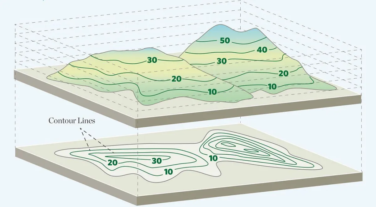
Topography and slope
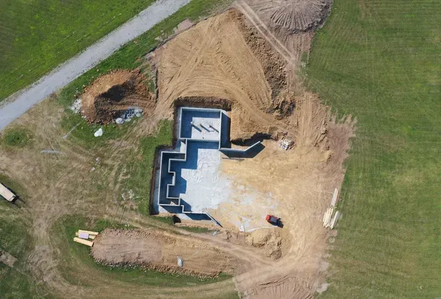
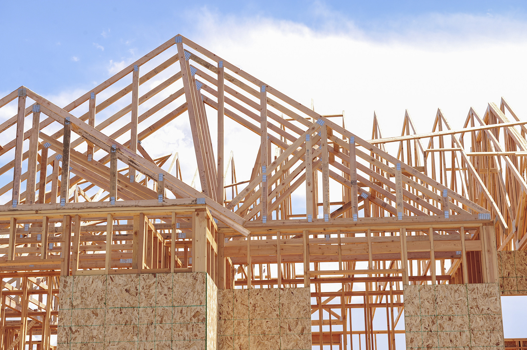
In the Roanoke region, many lots are uneven or sloping. Architects measure contour lines, slope percentages, direction of fall, and determine how building pads, foundations, and drainage will work. A steep lot may require retaining walls, stepped foundations, or additional grading—which affect cost and buildability.
Soil, geology and drainage
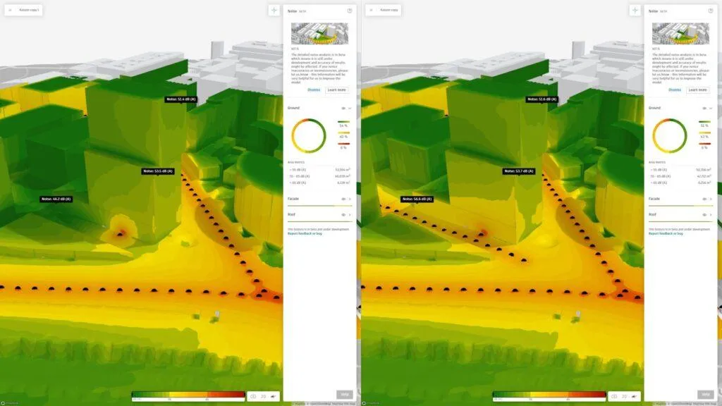
Before design begins, testing or reviewing soil reports is crucial. Are there rock ledges? Is the soil expansive clay? Where does water flow during heavy rain? In southwest Virginia, heavy winter/spring rains and spring‐thaw runoff matter. A good site analysis records where water goes, identifies potential erosion or pooling spots, and helps avoid building in a flood‐prone area.

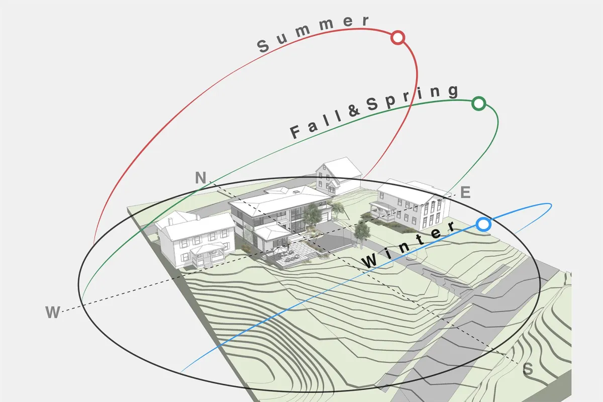
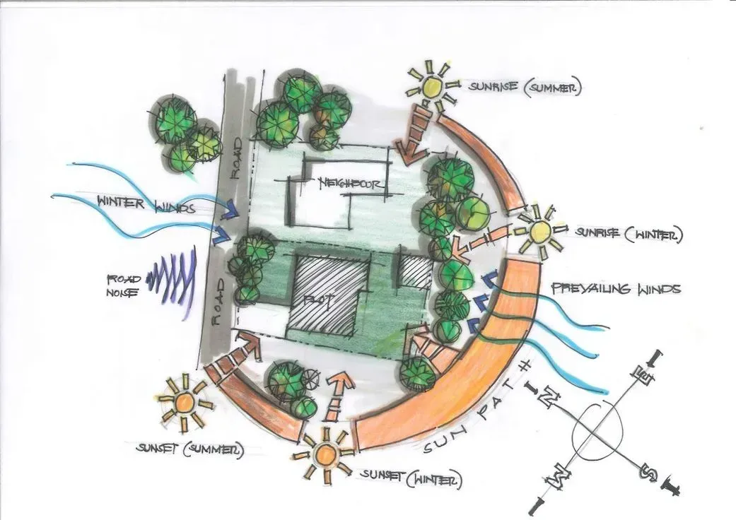
Orientation, sun and climate
Roanoke has distinct seasons: hot summers, cold winters, mountainous micro-climates. Architects evaluate sun path (to maximize daylight and passive solar gain), wind direction (for ventilation), and shading (trees or hills). For example, south-facing slopes may allow better solar access.
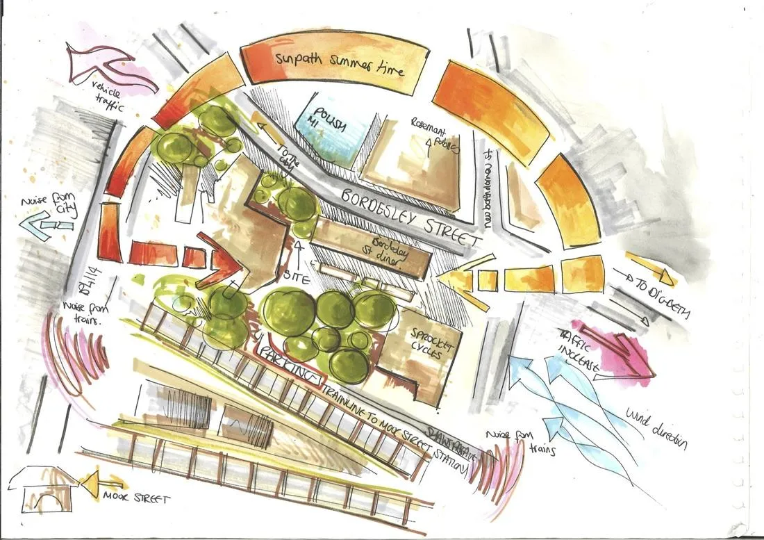
Access, traffic and orientation
How you get onto the site matters. Is the access off a quiet residential road, or is it near a busy highway? What about truck access, service zones, parking, pedestrian flow? For business owners in Lynchburg or Salem working with TAS Design, smooth site access and clear routing from the start prevent costly redesigns later.
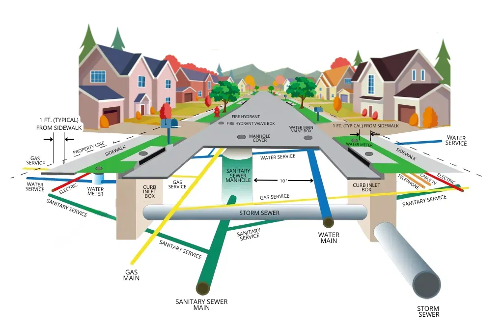
Utilities, infrastructure and zoning
Before design begins, knowing where utilities (water, sewer, electrical, gas) connect is vital. Local zoning in Roanoke and surrounding counties dictates setbacks, height limits, lot coverage, required parking, wetlands buffer zones and more. A site analysis compiles all of this so your architect designs within the law, not outside it.
Vegetation, views and context
Does the lot have mature hardwoods, rock outcroppings, southern views of the Blue Ridge Mountains? These become design drivers: preserve the tree line, orient the house to a view, or highlight a natural feature. In Roanoke’s mountainous terrain, the “context” of hillsides and views is often more valuable than the flat building pad.
How TAS Design conducts a site analysis (step by step)
1. Initial desktop review
The team gathers maps (topographic, zoning, floodplain), aerial photos, soil maps and municipal records for the site in Roanoke VA, Salem, or Botetourt.
2. Site visit and survey coordination
A physical visit helps catch things maps don’t show—bare rock, unusual trees, micro-topography. Coordination with a surveyor for detailed contours and boundary lines occurs.
3. Analysis of constraints and opportunities
- Identify steep slopes needing special foundations
- Map drainage paths to avoid building where water collects
- Highlight key views, solar orientation, wind shelter
- Mark utility connections, easements, wetlands, setback lines
4. Prepare site analysis diagram & report
TAS Design produces a clear drawing or board showing zones of buildable area, no-build zones, circulation, views, sun paths, access & utilities.
5. Use the analysis to shape the design
The schematic design reflects the findings—building footprint aligns with sun, walls back from negative views, driveway placement minimizes slope, etc.
6. Permit review and integration
The site analysis informs the permit-ready drawings so local officials (in Roanoke, Salem, Lynchburg) can quickly understand how the design fits the site.
Why it’s worth the investment up front
Skimping on site analysis may seem economical, but it often costs more later. Suppose grading is underestimated and additional retaining walls are needed, or a hidden rock ledge delays excavation. Or perhaps the house ends up with poor solar orientation and higher energy bills. By investing time and fees into proper analysis in the beginning, you get:
- Fewer surprises and change orders
- A design that feels right in the local climate and terrain
- Better energy performance and lower long-term costs
- Faster permitting and fewer local review snags
Local considerations unique to Roanoke / southwest Virginia
Designing or building in Roanoke and the surrounding Blue Ridge region brings a set of challenges and opportunities that are different from many other parts of Virginia. The rolling terrain and steep mountain lots that give this area its scenic beauty also make every site unique. Many parcels around Mill Mountain, Bent Mountain, or north of downtown Roanoke have dramatic slopes that demand careful grading and foundation planning. Rock outcroppings, shallow soils, and changing elevations can influence where a house or business can safely sit. During a site analysis, TAS Design Inc. studies these landforms closely to determine the best building pads, driveway approaches, and stormwater paths before the design begins. Proper planning early in the process prevents expensive surprises once excavation starts.
The region’s weather is another key factor. Southwest Virginia experiences heavy seasonal rainfall and freeze–thaw cycles in winter that can affect foundations, drainage systems, and soil stability. A good site analysis considers how water moves across the land during storms and how snowmelt might impact retaining walls or basements. Drainage planning is especially critical in hillside neighborhoods or rural areas near Smith Mountain Lake, where stormwater runoff can quickly cause erosion. Orientation also plays a major role: since Roanoke’s ridgelines and valleys often create microclimates, analyzing sun exposure and prevailing winds helps architects position homes for better natural light, passive solar gain, and comfortable outdoor spaces year-round.
Finally, local regulations and context shape how buildings fit into their surroundings. Roanoke and nearby jurisdictions like Salem and Botetourt County each have their own zoning ordinances that dictate setbacks, height restrictions, and environmental buffers—especially near streams or wooded areas. In older neighborhoods or rural communities, site analysis also helps preserve the local character by identifying mature trees, natural rock features, and important view corridors toward the Blue Ridge Mountains. Understanding these site-specific details early allows TAS Design Inc. to create designs that not only meet building codes but also harmonize with the natural and cultural landscape that makes southwest Virginia special.
Roanoke Architectural Site Analysis FAQs
Q: When should my architect begin a site analysis?
A: As soon as you’ve identified or purchased a site—or are seriously considering a lot. The earlier the analysis, the more influence it has on design and cost.
Q: What if my lot is already purchased and I skipped analysis?
A: It’s still worth doing a detailed site analysis—even after purchase. It may reveal hidden costs or design constraints you hadn’t anticipated.
Q: Does site analysis delay the project?
A: Not if scheduled properly. A good firm integrates analysis into the early phase so the schematic design flows from the findings rather than being delayed by them.
Q: Do small residential lots require the same level of analysis?
A: Yes, though the scale may differ. Even for an addition in Roanoke or renovation near downtown, understanding drainage, access, sun orientation and tree preservation matters greatly.


Up Next >
Up Next >
More Articles From TAS Design


Contact Us
Office Hours
Social Media
Mon- Fri 8 am - 5 pm
Sat, Sun- Closed except by appointment


Contact Us
1 540-302-2593
2507 Bluff Road
Roanoke VA 24014
Office Hours
Mon- Fri 8 am - 5 pm
Sat, Sun- Closed except by appointment
Social Media


2026 | TAS Design | Rights Reserved